We
arrived in Rikitea, the main village in the Gambiers on January,
18....It had been 10 days since we stepped foot on land. Up early the
next morning to check in with the authorities. We wanted to get it
done early, because our friends were hiking up the highest peak in
the islands, Mount Mokoto and they wanted us to go with them. The
weather was perfect for it.
The
village of Rikitea.
The
crew of Pakeatea, Sonja, Tom and son Keanu, followed by the crew of
Mango, Nick and Isabelle with kids Eric and Sophie, excited to see us
again. We last met in the Tuamotus.
One
of the buildings from the 1700s.
The
trees along the main road are huge, green and have a fur of baby
airplants living on their bark.
Interesting
flowers we had never seen before. They looked like very velvety red
fingers.
The
hill we are going to walk up, with the families just ahead of us.
We
are about half way up the hill, when we are treated with this view of
the island of Aukena, owned by famous Pearl mogul, Robert Wan.
We
went over a ridge and started going down hill, in the shade, nice!
We
found the trail entrance and we are in the jungle.
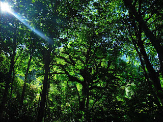
The
sun shining through some large trees.
These
are Ironwood trees, commonly used for carving.
We
come upon an area fenced off with barb wire where a spring is
located.
The
hill is pretty steep and covered with ferns.
Me
looking up a particularly steep part with Mike standing at the top.
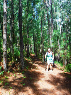
The
pine needles covering the trial were quite slippery.
A
new view to the North of the rest of the island of Mangareva and a
view of the barrier reef off in the distance.
Looking
through the pines at Mt. Duff, the more advanced hike, not to be done
with children.
This
is a shot from Tom, who was in the lead, looking down the steep hill
with the kids and Isabelle.
Tom's
shot of us coming though the high grass above the trees.
Looking
down at Rikitea village and our boats anchored out front, looking
East.
The colors of the water are becoming visible, along with the
many pearl farms out on the inner lagoon reef.
The
Southern group of Gambier islands, still inside the barrier reef.
Left to right, Isle Manui, Isle Kamaka, which has a small sheltered
bay, then very pointy Isle Makara with motu Teiki so close to the end
of it, they look like the same island.
Can
you see the inner reef (light colored water) between us and them?
Mike
and I pose for a photo with the southern group behind us.
Looking
East you see Mount Duff on Mangareva, a bit of Isle Aukena, a big
puffy cloud by itself and the Isle of Akamaru on the right with a
large shallow reef on its North side.
The
lichen on this volcanic boulder made some interesting formations,
reminded me of tattoo characters.
But
wait we are still not at the top!! More virtical-ness to go! Can
you see everyone just going over the next ridge?
The
island of Teravai, inside the West corner of the barrier reef.
We
are up so high, we can see the white cloud reflected in the blue
water. It is almost surreal.
Great
shot of Akamaru.
Almost
at the top of the peak of Mount Mokoto!
To
get a little perspective of the hill, I wait for the others to go
ahead. Mike, Isabelle, Sonja, and the guys with the kids on the last
little bit.
Tom's
shot of me looking back down the hill from his perspective.
A
snack well earned! We all munch out while enjoying the view. Sonja
and the kids.
Tom,
Sonja, and Keanu with Teravai in the background.
Tom
gets a shot of me as my hat is tipping my sunglasses up and you can
just see me looking under them. Funny!
Mike
resting enjoying the view.
Mike
and I with Mt. Duff behind. If we look a little hot and sweaty, it's
because we are!!
The
point of Mangareva that looks West and we can see the pass where we
came in yesterday.
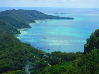
Isle
Teravai, which will become one of our most favorite spots.
However
if you blow up this photo, you can see the crazy reef system guarding
the bay. It is a butt puckering zig and zag course to get in where
those boats are anchored!!
On
the North side of Mangareva it is extremely shallow! And you can see
that sweet wonderful barrier reef that keeps the big Southern Ocean
swells away.
The
very blue water is around 80 to 150 feet deep. The light blue is
about 10 to 20 feet deep and the dark green is looking down on the
coral shelf around the island, 0 to 10 feet.
Time
to start heading back down the ridge through the high grass and past
a balancing rock.
Tom
stayed behind in order to take a very special photo of all the
islands.
This
is Tom's 360 degree of the world view from the top of Mt. Mokoto!!
Thanks for sharing this with us Tom!! Note the shear cliff of Mt.
Duff and all the big puffy clouds on the horizon.
OK
people, stay on the trail, please, it is steep over there!
One
area was so steep that Sophie and Keanu were sliding on the leaves.
The
gang waiting for me in the pine needle trail on the other side of the
ravine.
Tom's
shot of me coming down the other side.
Mike
and the kids sit on a big root outcrop and use it as a bench.
There
is that spring water heading down the gulley!
We
have started calling these big black hoses, used to pull the water
from the spring, Big Black Tahitian Water Snakes.
Can
you see the little lizard on the stick of wood. Dead center.
At
the end of the trail, Tom gets all the kids together for a photo, on
top of a big rock.
Kiddos!
Sophie and Keanu both 7 in the front and Eric, 4 in the back. You
might think they did pretty good for being so young, but then again
they are German and Austrian!!
We
spot a huge banana stalk of bananas hanging on the side of the road.
These
guys are prepared, with a machete, they hack off a few.
These
are called Angel flowers.
Back
in the village at the Quey, all of the kids are jumping in the water
to cool off. I think kids do this everywhere in the world! There
are a lot of them!
AS
we watch the sun set glow on the clouds, we start to feel our legs,
they were wobbly on the way back and now we realize, we should
probably not gone hiking with Germans and Austrians after 10 days of
not touching ground! Oh well, it was worth it for those views!
Seeing it all from up there, now we can't wait to start exploring!


